2: Indeed. It makes the US look like a Wookiee.
Woo, coworkers!
My only complaint is that I'd like to be able to flip to or overlay actual map tiles. I'm particularly interested in the places the wind seems to diverge around, leaving stillness at a small point. There's one about halfway between St. Louis and Nashville, for example.
It also goes well with this NASA ocean current visualization.
My only complaint is that I'd like to be able to flip to or overlay actual map tiles. I'm particularly interested in the places the wind seems to diverge around, leaving stillness at a small point.
You can zoom in pretty close, but it looks like the only landmarks it gives are a handful of cities.
I'm kind of surprised by how vorticity-free it looks. Although I guess if you could zoom out to more of the globe that might stop being true.
5: That may just be what it happens to be like right now. The patterns vary a lot.
Yep, there's some definite whorliness in some of those.
I had no idea that there were large chunks of the US with regular easterly winds. I guess it's because the Jet Stream gets all the hype.
Yeah, one thing this really shows is just how complicated the patterns are when you look at them in detail, which tends to get overlooked in discussions of broader trends.
9 is one of those Universal Comments.
9 is one of those Universal Comments.
I intend to link back to it frequently in future threads.
I'm particularly interested in the places the wind seems to diverge around, leaving stillness at a small point.
PAY NO ATTENTION TO THOSE AREAS, CITIZEN. JUST MOVE ALONG NOW.
12: Oh teo! You're such a maverick!
Or so the mullahs would have you believe.
||
Doop de doo. I think I'm going to put on this Earl Scruggs record, read some Adrienne Rich, and masturbate.
[turns on radio]
Oh noes!
|>
I got a link to the ocean current visualization some 60 seconds before seeing this post, was excitedly going to post it, then comment 3 cast me into a slough.
Nice to see this was built in HTML 5 and not Flash.
How do they know all this? I am assuming they have a giant national network of correspondents standing around with little wind socks?
20: The note at the bottom says the data is from the National Digital Forecast Database.
Which implies that it's actually forecast rather than observation data.
22: At least as of about 7-8 years ago, the grids were still somewhat artisanally hand-crafted (.pdf):
Q. How are the grids actually made (Forecast and mosaic process)
A. Forecasters in over 120 Weather Forecast Offices around the country apply considerable local weather knowledge and meteorological skill to the creation of the grids that go into the National Digital Forecast Database or NDFD. Each office is responsible for the grids over a specified area typically about the size of the state of West Virginia (the size of each area varies based on local geographic considerations). Forecasters at each office coordinate individually with forecasters at neighboring offices to generate grids that are meteorologically consistent in both space and time. When the grids are completed in this fashion locally, they are then sent to the NWS computing facility in Camp Springs, Maryland and combined into the gridded forecast mosaic known as the National Digital Forecast Database. The grids are often updated at individual offices. To allow for this updating, the NDFD data is updated with the latest data at the top of the hour.
8: I had no idea that there were large chunks of the US with regular easterly winds.
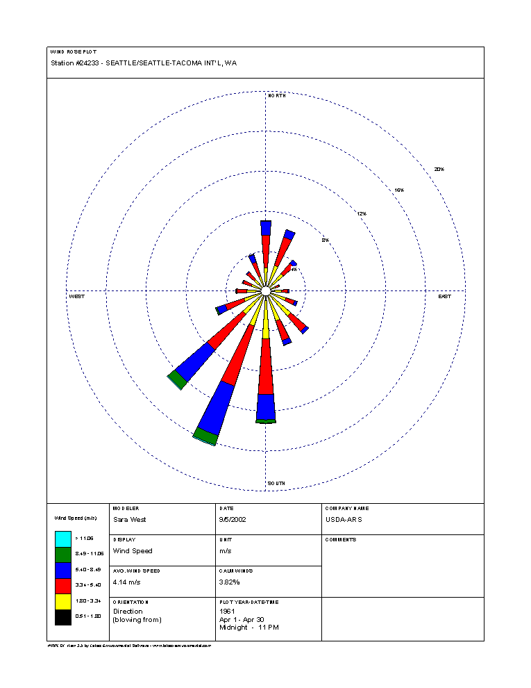
Not sure how you are exactly reaching that conclusion from the data shown here which is a point in time. But yes, although there is a general net west-to-east flow across the continent (but much more pronounced at Jet Stream levels of 20,000-40,000 feet) it is much more complicated in detail (and varies through the year). Florida is a place with regular easterly winds, for instance. Here is a directory of wind roses by month for major US cities. Here's Pittsburgh in March when the stronger winds are very much from the west, but lighter breezes are much more widely distributed.
A handy heuristic is to look at the directions of runways which tend to be along the axis of prevailing winds. And the runway "name/numbers" give that info since they are the magnetic compass heading* divided by 10. 27 is 270° and in the other direction it is 09 (90°). Atlanta for instance (.pdf).
*Yes they can change over time (very infrequently). At some point as you go north they use true north since the magnetic heading varies more significantly.
24.2: An example is Seattle's N-S runways, which are consistent with its winds (for instance, March).