Pakistan has the most glaciers of any non-polar region
I wouldn't have guessed this no matter how many tries I was given.
I mean, how many tries would you need before you even started to make guesses that were about the locations of glaciers.
I wonder if/when climate change will become a trigger for anti-US terrorism.
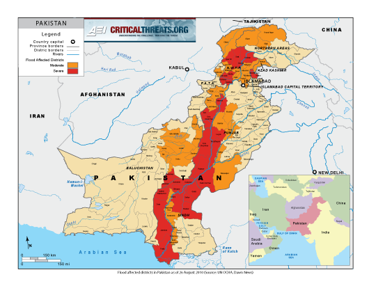
The thing about Pakistan is that the whole country is essentially one giant river valley surrounded by huge mountains. So when the river floods catastrophically it takes out everything.
(The 1/3 underwater figure presumably refers to the river valley, not the entire area of the country which is mostly sparsely populated mountains and deserts.)
1: I think I'd have guessed China and Nepal first, but surely I'm pretty sure I would have gotten it third or fourth (maybe I'd have said India?). It has to be the Himalayas, and all the tallest ones are in Nepal or Pakistan, so it's a pretty sensible guess.
I'm baffled about where the 1/3 figure comes from, no one seems to know. Maybe it means 1/3 people live in the flood zone?
I read somewhere that it originated with some local politician or something, presumably with a specific political angle that it helps. Very hard to track down the source though.
I guess I thought that literally one third of the land area was flooded.
There's just no way it could be literally true of the whole country. Pakistan is huge and most of it isn't remotely vulnerable to flooding in an ending-up-under-standing-water way.
Yeah, the 1/3 is probably just a completely made up statistic.
I was assuming it was population-adjusted, but the link says 33 million people have been affected and the total population is 221 million; that's less than 1/6.
I bet it comes from looking at a map, and not thinking about how topology affects acreage. That is, on a flat map, probably 1/3 of the map is shaded to indicate regions that are flooded.
7. Your reasoning is sound, but Pakistan is orders of magnitude bigger than Nepal, and its mountainous regions are probably bigger than the whole of Nepal. But I too would have guessed China or India first because they're so damn big I sort of assume they win at everything geographical.
I was always taught that there were 640 acres to a square mile, and that's that. Maybe it didn't matter because there were no hills.
15: Here's a flooding map (the one below "...ravaged towns and upended lives"). It looks apocalyptic in scale since it also folds in topography and population density so you can see how much of the non-flooded parts are mountainous and empty, but it still doesn't look anything like 1/3.
Pakistan looks small on maps because it's next to China and India, which are much bigger, but it's actually a really big country by any standard. One of the biggest in the world by population and definitely in the upper half by area.
20: Thanks, I was looking for articles that had maps. That's a lot of flooding but still not even close to 1/3 even of the riverine area. And the maps even cut off like 1/4 of the country!
Maybe it's by volume and Pakistan only claims a very slight airspace?
20: I think you could get to 1/3 by eyeballing this map.
Maybe they stopped counting Kashmir.
Yeah. This longish compilation of glacier info from satellites from USGS shows a different result.
State of the Earth's Cryosphere at the Beginning of the 21st Century:
Glaciers, Global Snow Cover, Floating Ice, and Permafrost and Periglacial
Environments--
Ha! 26 meant to just be a preview...
But they have estimates of glacial areas:
China 59,406
India 16,755
Pakistan ~15,000
No idea how they allocated disputed areas between the three (which are right where many of the glaciers are) but it sure seems that China (in which of course the biggest portion of glaciers is in Tibet and then Xinjiang) has an insurmountable lead. Paper is odd in that there is no date, but it I saw references to at least 2010.
This is about the most detailed map I could find. Hard to see the borders where the 3 meet (the disputed borders are shown less prominently). China does have most of the Tien Shan in addition to the Kunlun and Himalayas as well as scattered stuff on the Tibetan Plateau). I think Karakorum is mostly Pakistan and some India.
18: Yeah, I mean I think any of those four countries is a sensible guess, and anything outside those four is not a good guess (I mean you could get fancy and guess Kyrgyzstan I suppose, but that seems pretty unlikely). I just don't have a great sense of how big a role the size of Pakistan is playing here, the vast majority of it obviously doesn't have glaciers. Like if you told me 90% of the glaciers in Pakistan fit in an area smaller than Nepal around K2 I'd believe you...
Oh wow, thanks for the map! Tajikistan is a big surprise to me.
But yeah, I was right in 29, the size of Pakistan plays almost no role, it's just that The Kanakoram has a lot more than any else. I was expecting the line along Nepal to be comparable in size to the line along The Kanakoram, but it's just not comparable at all.
I did consider Afghanistan as a guess, but it's just so obviously going to be dominated by Pakistan that there's no reason to guess it for first.
Anyway the key fact you need to know here is that K2 is in Pakistan. If you don't know that then it becomes a much harder guess to make.
IIRC back when they had the really bad floods in central Europe, in I think 2002, one-third of the Czech Republic really was under water. (I was in Prague later that year. It was damp and very quiet and the buildings had a tide mark on the walls that was disturbingly far above head height)
This map *about 2/3rds of the way down the coast) does not show glaciers, but it is a nice representation of the mountain ranges of central Asia which can be hard to untangle on most maps.
"([A]bout 2/3rsd of the way down the page) that meant to say.
16-17: Let's call the whole thing off.
re: 34
Yeah, I was there a matter of weeks after the floods and even a few months later there were trees in the grounds at the Troja Palace that were filled with plastic bags where the high water line was, and the bags were something like 20ft up. My wife's parents live near where the Vltava meets the Elbe and that area was very flooded (not their village which is a bit higher up).
Friend of mine lived quite near the Vltava and when her family returned from evacuation they found a dead body in their rhododendron bushes. (Washed out of a cemetery upstream rather than drowned. But still.)